Deaconess Trailhead
Amenities:
-
Parking
-
Water fountain
-
Bike loops
-
Bike air pump station
-
Picnic tables
-
Shade structure
Trail Connections:
-
Friedman Park: 0.8 miles
-
Victoria Woods Trail: 2.0 miles
-
Upgrade Trailhead (Vann Park): 1.8 miles
-
Nevins Trailhead: 2.0 miles
-
Toyota Trailhead: 2.5 miles
Description:
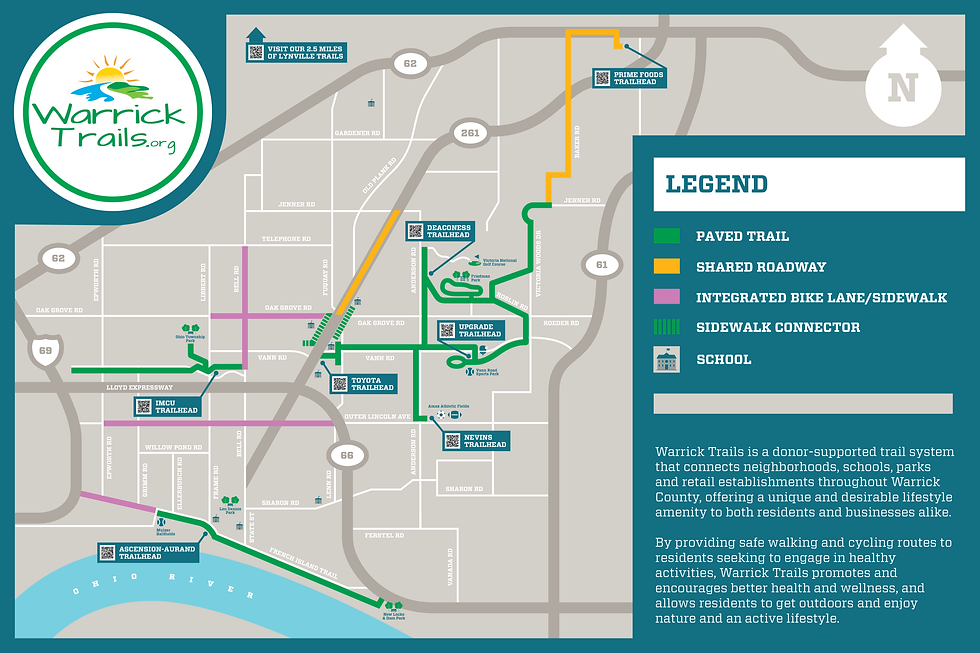
Deaconess proudly sponsored the trailhead located on Anderson Road, a central hub within the Warrick Trails system. This trailhead plays a key role in connecting multiple trail segments and serves as the starting point for the Old National Bank Loop, a popular route for walkers, runners, and cyclists.
Deaconess Trailhead offers convenient access to Friedman Park, located just 0.8 miles away, and connects to several key destinations, including the Upgrade Trailhead at Vann Park, Castle High School to Castle South Middle School, and Amax Fields via paved trail.
We are grateful for Deaconess' investment in community health and wellness through their support of this vital connector in the Warrick Trails system.

ONB Loop
Trail Connections:
-
Friedman Park: 0.8 miles
-
Victoria Woods Trail: 2.0 miles
-
Upgrade Trailhead (Vann Park): 1.8 miles
-
Nevins Trailhead: 2.0 miles
-
Toyota Trailhead: 2.5 miles
Description:
The Old National Bank Loop is a 4.75-mile paved trail loop that begins and ends at the Deaconess Trailhead on Anderson Road. This well-connected, multi-use loop is a favorite among walkers, runners, and cyclists for both recreation and commuting, and it showcases some of the most scenic and active areas of the Warrick Trails system.
Starting at Deaconess Trailhead, the loop travels 0.8 miles to Friedman Park, then continues along a dedicated path on Roslin Road. At approximately 1.4 miles in, trail users will find a spur leading to the Victoria Woods Trail, which includes a picturesque bridge crossing surrounded by natural beauty. From there, the loop connects down Vann Road, providing direct access to Vann Sports Park (Upgrade Trailhead) before circling back to complete the loop at Deaconess.
In addition to its primary route, the Old National Bank Loop offers connections to several key destinations via spur trails, including:
-
Victoria Woods Trail
-
Amax Trail and Nevins Trailhead @ Amax Fields
-
Castle High School / Toyota Trailhead
-
Castle South Middle School
Thanks to the generous support of Old National Bank, this loop serves as a cornerstone of connectivity in Warrick County, promoting healthy lifestyles and active transportation for all ages.

