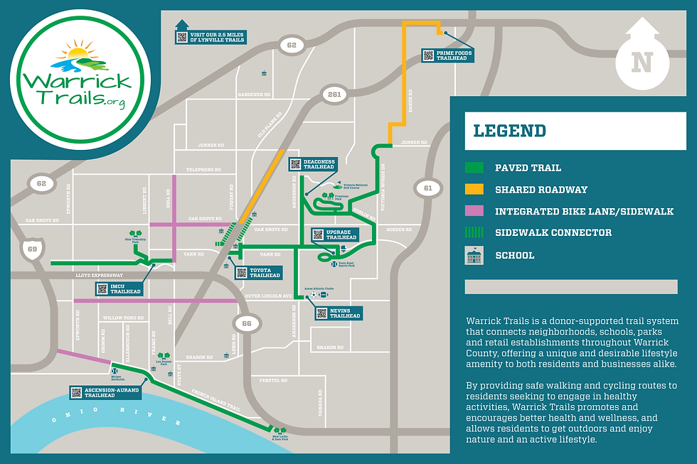
IMCU Trailhead
Amenities:
-
Parking
-
Bike loops
-
Benches
-
Water Fountain
Trail Connections:
-
Ohio Township Park: 0.5 miles
-
Sports Complex: 2.0 miles
-
Friedman Park: 6.1 mile (via sidewalk and trails)
Description:
The Indiana Members Credit Union sponsored the IMCU Trailhead is located at the Newburgh branch parking lot. With this partnership, a covered bench area, water fountain and bike rack area that connects to the 1/2 mile High Point Trail along High Point Dr. connecting the bank to restaurants, apartments and shopping centers.


Wellness Trail
Amenities:
-
West End (Epworth Rd)
-
Parking @ Ascension
-
-
Benches along trail
Trail Connections:
-
West End:
-
Sports Complex: 0.5 miles
-
Ohio Township Park: 1.75 miles
-
IMCU Trailhead: 1.6 miles
-
Friedman Park: 7.7 miles (via sidewalk and trails)
-
-
East End:
-
Sports Complex: 1.9 miles
-
Ohio Township Park: 0.35 miles
-
IMCU Trailhead: 0.1 miles
-
Friedman Park: 6.2 miles (via sidewalk and trails)
-
Description:
The Wellness Corridor Trail is a 1.5-mile paved asphalt path running through the heart of the region’s wellness corridor, beginning off Epworth Road. At 8 feet wide, it is bike- and stroller-friendly, providing a safe and accessible route for walkers, runners, and cyclists.
This trail connects multiple healthcare facilities, hotels, apartments, and restaurants, making it both a recreational and practical route for the community. It links directly to the High Pointe Trail and is just 0.5 miles from the new Ohio Township Park, offering easy access to additional recreational opportunities.
Whether for exercise, commuting, or a leisurely stroll, the Wellness Corridor Trail provides a safe, scenic, and convenient pathway through one of the area’s most active and connected neighborhoods.